Dalhart Weather Review
By Aaron Graves
 |
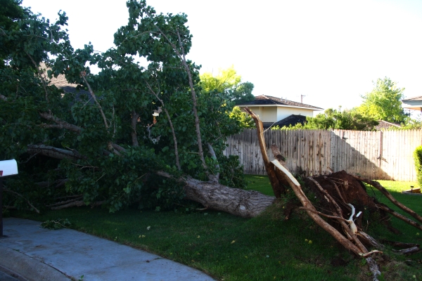
| One of several trees blown down on Sunday. |
My rain gauge on the southeast side of Dalhart picked up 2.90” between Friday and Sunday. The National Weather Service office in Amarillo recorded a total of 1.94” of rain at the Dalhart airport southwest of town. Our official year-to-date total precipitation is 3.78”
Elsewhere, an observer three miles east of Channing reported 0.70” to the NWS. Texspivot.com reports farmland near Texline generally received about 1.40”. Rain totals north of Dalhart near Hwy 385 were between 1.50” and 2.0”. Rain totals were similar along North Sedan Road. Isolated spots in these areas saw over 2.0”.
South of Dalhart, rain totals approached 4.0” in places. The Hartley area saw between 2.0” and 2.5” of rain. South of Hartley generally saw 1.5”. Rain varied from 0.6” to 1.5” in western Hartley County.
Friday’s storms carried a strong tornado risk with them, drawing storm chasers from several states to the area, including the famous Tornado Intercept Vehicle, or TIV, as seen on the Discovery Channel. A tornado warning was issued Friday evening, which included the cities of Channing, Hartley and Dalhart, as a funnel cloud was reported north of Channing. Motorists battled blinding sheets of rain on Hwy 87 between Hartley and Dalhart.
UPDATE: I got double confirmation from the Amarillo NWS that there was indeed a tornado, not just a funnel cloud, 10 miles northwest of Channing, that stayed on the ground for 8 minutes. Apparently, nothing was damaged. (My report of no tornadoes in "The County Times Two" was in error due to a miscommunication with the NWS.)
Sunday’s storms did not look as menacing as Friday’s, but they carried quite a punch. Several trees were blown down around Dalhart, and a power pole on Hwy 87 was blown over, knocking out power to the southeastern part of town. Tree damage seemed most intense between 7th and 16th from about Denrock east to Hwy 87. Large tree limbs lay in the road along Tennessee Ave and along 11th Street. Power was out on some streets in that area as well. Again, anyone caught on the road had to deal with blinding curtains of rain.
UPDATE: How strong were the winds on Sunday? The Amarillo NWS recorded a peak wind gust of 48 mph at the airport. According to the Beaufort Wind Scale, which is used to determine wind speed by it’s affects on land and water, trees can be uprooted with wind speeds between 55 and 63 mph. "All of our observing sites and reports from spotters and chasers indicated gusts around 50 mph," said Todd Lindley, Science and Operations Officer at the Amarillo NWS. "In wet soils, that can be enough to blow down trees."
The storms dropped our daily high temperatures from the mid 80's to the low 70's. Temperatures should stay mild through Friday until climbing into the mid 90's on Saturday. We could see a stray thunderstorm or two through Friday.
High and low temps the past week
Jun 3: 99, 64
Jun 4: 92, 64
Jun 5: 85, 65
Jun 6: 86, 63
Jun 7: 71, 59
Jun 8: 73, 57
Jun 9: 70, 52
No comments:
Post a Comment